Blogroll
- Meals I Have Eaten
- Jess's New Blog
- One of Jess's Old Blogs
- The Stop Button
- Jenerator's Rant
- The Rejection Collection
- Pockets Stuffed With Notes
- The Silkie Road
- PostSecret
- Informed Comment
- Talking Points Memo
- Spoken & Heard
- Ever So Strange
- that-unsound
- Marvelous Prompts (& Responses)
- Only Words To Play
- So Misunderstood
- Acknowledge & Proceed
Profile & Email
Previous Posts
- a visit from salvation
- bee-'ba-dee-dee-ba-dee...
- between moss & a vine
- protection means going that extra distance
- recent additions
- little publish
- if you turn to me like a kite to the wind…
- Dear Evil Arch-Nemesis,
- drag queen on the wall
- ash accuracy
Archives
- April 2005
- May 2005
- June 2005
- July 2005
- August 2005
- September 2005
- October 2005
- November 2005
- December 2005
- January 2006
- February 2006
- March 2006
- April 2006
- May 2006
- June 2006
- July 2006
- August 2006
- September 2006
- October 2006
- November 2006
- December 2006
- January 2007
- February 2007
- March 2007
- April 2007
- May 2007
- June 2007
- July 2007
- August 2007
- September 2007
- October 2007
- November 2007
- December 2007
- January 2008
- February 2008
- March 2008
- April 2008
- May 2008
- June 2008
- July 2008
- August 2008
- September 2008
- October 2008
- November 2008
- December 2008
- January 2009
- February 2009
- March 2009
- April 2009
- May 2009
- June 2009
- July 2009
- August 2009
- September 2009
- October 2009
- November 2009
- December 2009
- January 2010
- February 2010
- March 2010
- April 2010
- May 2010
- June 2010
- July 2010
- August 2010
- September 2010
- October 2010
- November 2010
- December 2010
- January 2011
- February 2011
- March 2011
- April 2011
- May 2011
- June 2011
- July 2011
- August 2011
- September 2011
- October 2011
- November 2011
- December 2011
- January 2012
- February 2012
- March 2012
- April 2012
- May 2012
- June 2012
- July 2012
- August 2012
- September 2012
- October 2012
- November 2012
- January 2013
- March 2013
- May 2014
n. infantile pattern of suckle-swallow movement in which the tongue is placed between incisor teeth or between alveolar ridges during initial stage of swallowing (if persistent can lead to various dental abnormalities) v. [content removed due to Bush campaign to clean up the internet] n. act of nyah-nyah v. pursuing with relentless abandon the need to masticate and thrust the world into every bodily incarnation in order to transform it, via the act of salivation, into nutritive agency
Thursday, June 15, 2006
Kayak Trip – Cypress Island
 “I have a friend, a biology specialist, who pointed out that we’re at a point where all the animals currently proliferating are ones that carry disease: rats, insects and so forth.”
“Mmmmm.”
“You hear how they recently had the first case reported of human-to-human transmission of the Avian Flu?”
“Nope. You kidding?”
“I’m not kidding. And I’ve seen projections that show how that flu could wipe out the entire population of a city the size of Seattle in a 24-hour period of time.”
“Do you mean the size of Seattle for the whole population of earth, or Seattle all by itself and other cities following its pattern?”
“I mean Seattle by itself, because it has a high degree of trade with Asian countries, where the human-to-human transmission occurred.”
“Oh. They have an immunization for it, don’t they? But they can’t produce enough of it. I read somewhere that they are starting to “dole” it out in certain states. Why can’t they produce enough of it?”
“Because they don’t want to. Pharmaceuticals aren’t interested in sharing the recipe or cutting their profits.”
“But if you’re talking about wiping out a city the size of Seattle, how would they prevent riots against them?”
“Dole out the immunizations. Doesn’t it make you wonder who they’re doling it out to?”
“Nat?”
“What?”
“We’re on vacation. Can we not talk about this anymore?”
“Oh. Okay.”
***
That is to say: it was a kayaking trip replete with ghost stories vicious enough to scare the crap out of me. But it was also just perfectly right.
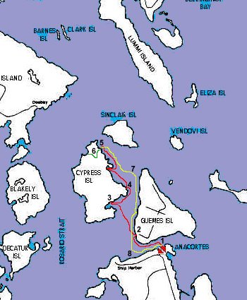 I’ve mapped out our route – with the red line being Day 1, yellow being Day 2, and green being our evening hike from Pelican beach to Smuggler’s Cove.
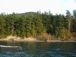
 We basically put out our two-person kayak from the mainland, leaving from the Guemes Island Ferry terminal (1) and paddling north through the B--- Channel, which divides Guemes and Cypress Islands. We camped on the north end of Cypress—at Pelican beach (5), where all the islands on the east side of this map were visible… including the mainland of B--- harbor.
Before heading out, I checked the Marine Forecast and the tide charts, and decided the trip was a definite do-er. The winds were supposed to be light to 10 knots, and the weather was supposed to be sunny with bouts of thunderstorm. Sounded good to me: dramatic, but mellow.
The tides were with us, ebbing in the morning and flowing in the afternoon. Since the currents run west on the ebb (from 1 to 8) and east on the flow (8 to 1), we could put out in the morning and run with the tide along the base of Guemes Island. We could then take a pause on the beach at 2 and wait for the tide change. Through the channel, the currents run north on the flow (from 2 to 5) and south on the ebb (from 5 to 2), so after waiting a half-hour or so on the beach, the tides would hypothetically push us in the direction we wanted. The next day, we could just reverse the morning and afternoon movements…
This was of course, all hypothetical, and I found that the current changes were a little slow, which meant there was a bit of a fight crossing the channel on the first day, but after that we were better-timed, and the currents didn’t give us too much trouble.
So, going back a little, my good buddy, Nat and I met up at the ferry terminal after Nat got herself a speeding ticket (whoops) and showed up late. I was just happy she could come; communicating had been a cellphone extravaganza the weekend before we went, and I was fretful about whether she was going to make it… right on through the gathering and packing of gear and the grocery shopping to keep us both fat and happy. But we did meet up, and the only crappy moment was when I realized I had left the camera batteries in the re-charger back home.
Yeah, super-sucky stupidessa. So, I’ve nabbed a bunch of photos off the web, and for your pleasure, Photoshopped myself or the kayak into a few of them. Let’s see if you can tell which ones…
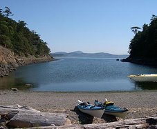
 The first adventure was discovering geoducks, these absolutely monstrous clams that stick their siphons up out of mud beaches and squirt at you when you pass, on the resting beach (2). Also present were tons of eel pouts, which Nat claims are “icky,” although I love catching and holding them as the flap around in my hand. Bitty crabs crawled around, and tons of snails, limpets, starfish, tube worms and tanzanian sea monsters. Nonetheless, the weather was chill and so we took to the other side, where a salmon fish camp was replete with jumpers (3).
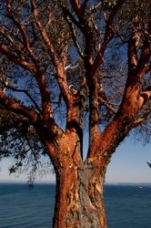 This side of channel looked quite a bit different, I think because there’s no ferry that takes people there, and so it’s not at all built up. Guemes has beach houses and windmills and such as you go along, whereas Cypress seems to have quite a few more of my favorite trees in the whole world—Madrone trees, with their peeling skin and red underbellies. Madrone’s are picky trees, as it were, and will only grow where there is a great deal of free water flow, such as on the edge of cliffs. They also need lots of sun and heat, and so tend to grow near the ocean where the water reflects an additional quantity of sunlight in their direction. I think there must be other qualities they pickily look for in their neighborhoods because I never see very many of them unless I’m in the San Juan Islands…
From the fish farm, we scuttled northward, hugging the shore around Cypress Head (4), where the currents are supposed to be wicked. We must’ve hit it at the right slack time, because there were no currents to speak of, only lovely flat calm, on the way north. It wasn’t until the way back that we ran into some wicked ferocious currents…
 We lunched on the beach at Cypress Head, which we had to ourselves and the fire ants, and then Nat and I decided to continue on. My shoulders started aching right at our second rest stop along the red path – we stopped two other times and explored the shore, because we had time and it felt good to stretch. I realized I’m not the only out-of-shape one, because although Nat is almost the most fit person I know, it is truly hard to keep your shoulders in kayaking-form. So we paused quite a bit and tried to convince the currents to push us onward.
Right before we got to Pelican beach, there were a few rips that we had to look out for, but they weren’t too bad, just unexpected. The above map doesn’t show the “Cone Islands,” which are tiny little knobs just south and east of Pelican, and they tend to put a little eddy into the waves that run downward from the tempestuous Rosario Straits.
 Pelican Beach was a friggin haven… we had it all to ourselves after an enclave of touristing high-schoolers who yodeled REM left. The sun was out when we arrived, and the camps right up along the shore were empty and lined with great batches of wild roses, which are some of the best-smelling flowers around. The thing I like about wild roses is their subtle lure. You can shove your nose right in them and they smell less potent than the cultivated ones, but if you are walking around, their collective humidity absolutely sweats the air in scent.
 The DNR site is completely free as long as you pack-in, pack-out, and respect the completely eco-driven outhouse that is provided by the good folks of the marine highway. This is pretty great since Pelican Beach is as ritzy a true campsite as I’ve ever been to, and even has a boardwalk lining the campsites.
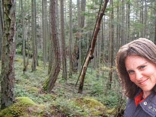 Nat and I took a brief rest in the sun—some of us even resorting to snoring—and then we took the hike over to Smuggler’s Cove (6), which I wanted to visit because of its name. As we hiked the path across, we ran into Duck Lake, which was completely covered in lily pads and had several bald eagles perched above the water, scouting for frogs or something like that.
 But the best part of the trip, aside from the above ghost-story conversation, was the discovery of a sign about the previous owner of Cypress Island… a woman who lived by herself for years, building cabins and out-building for her animals and cultivating the land near Duck Lake. Apparently she posted “No Trespassing” signs all over the place, and wasn’t known to be very friendly. At the end of our history of her, she sold her boat, got dropped back onto Cypress, banned any visitors to the island, and then simply disappeared… never to be found again.
I liked writing that. "Never to be found again..." It was fun.
Nat’s comment was: “The death of another writer.”
And my comment was: “Or a closeted lesbian.”
But we found what I think must have been one of her animal stables (log cabin, no windows and some gappage between the stacked logs) on the path up from Smuggler’s Cove. The ceiling was done in, and the place signed as dangerous, but it was haunting to look at and imagine this woman’s life, and the life that existed before to give Cypress such names as Smuggler’s Cove.
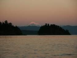 We got back from our hike pretty near sunset, and watched things settle down purple and grey over the Straits. The evening came with a campfire, packed in chicken and apples, and some chocolate (but no smores). A great noise that sent us in temporary panic turned out to be a mere deer, and the two of us fell asleep next to the fire and later dragged ourselves to the tent. As it turned out, the only thunderstorms we faced that trip came during the night, along with little mice, one of whom ran over my hand in the dark.
I dreamt I was in a new body, and my presence in this new body was making it incredibly fat.
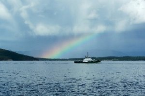 The next day was cloudier and the currents looked a little wicked. A sharp splinter of rainbow hovering out over Vendovi Island made me think rainstorms were heading our direction, so we set out early. Sure enough, a fair amount of current out there although the wind couldn’t have been much above 5 knots. I could see a bunch of whitecaps from the current around Cypress Head, so we cut across the channel northward of the currents (7), and zipped along down the west side of Guemes Island.
 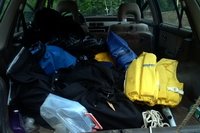 We made quite good time, even though we stopped for a snack on the island, that we had time to paddle along Anacortes ship harbor (8), going in and out of the dock pilings, and admiring the old boat junkyards, rusting metal tugs, and falling down canneries along the shore from the harbor to the ferry terminal. Finally we got home safe and sound and shot off like to hot darts to find some coffee and gossip about community art projects…